Wednesday, November 30, 2016

Better Than Solstice - WI3, 150m (3 pitches)

November 24, 2007 I led the first ascent team on this slacker WI3, eh, hard to get FA's. I spotted this waterfall solo scrambling/traversing Mt. Bryant back in 2006. Jason, TJ and I had fun on this route in 2007, so fast forward to fall 2016, I thought I would head back here with John for some early season fun.

Back in '07, the ice quality and quantity was better than John and I had this year. http://www.gravsports-ice.com/icethreads/ubbthreads.php/topics/217/Better_Than_Solstice,_F&D

In the lower section the ice was not well attached to the rock, was super dry and aerated and where it transitioned from near vertical to lower angle, was only about 1 cm thick; difficult to protect. After the first 30 metres, the ice improved greatly.  John and I had a lot of fun of this early season route.


Mt. Bryant from the parking area.
View of BTS from creek.

zoomed in view of BTS

First pitch of BTS, F & D to left, not safe to  climb.

John having fun.

View down from first belay station.

View up from second belay station.

Friday, September 30, 2016

GR 396219 “Little Tombstone” - "Janelea Mountain" | Scramble, South Ridge

After our ascent of South Schlee, we spent Sunday night in the same camp in upper Piper Creek, then at first light moved camp over Piper Pass. Originally we had hoped to ascend “Ripsaw” (GR373253), but the approach was too long for the short days, so we decided to ascended “Little Tombstone” (GR 396219).  We set up the tent about 2 kilometres north of the pass along a beautiful larch tree lined bench, then hiked down the steep headwall, across the valley and up the simple east slopes of Little Tombstone. 

We did gain the South Ridge up to the southern summit (had a fun series of towers that we scrambled up), then hiked up the South Ridge to the summit, bypassing one tall/steep gendarme. 


Route up and down Little Tombstone.


On the summit we found an old small jar (baby food maybe) in the summit cairn.  The only entries were:

“Janelea Mountain” S. Toporowskj and D. Smith, July 3, 1975. Ascent by North Ridge.

Jim Palmer, Rita Polt and Jerry Piro. September 11, 1977. Ascent by East Ridge.

John Martin. August 19, 1986. Ascent by East Ridge.

Also an entry I couldn’t read. I kept our entry simple since paper was brittle and falling apart). Kevin Barton, Scott Berry. September 19, 2016. South Ridge.


Old registry, 1975.


Scott and Kevin on the summit of Little Tombstone.
Our summit entry.

Quick descent, basically straight west down the slopes, avoiding the few steep slab sections. Then across the meadows and light bush of "Paradise Creek" and a tough scramble up the headwall back to camp.  We got back after dark, finished our small supply of whiskey and headed to bed.  We woke up to about 20 cm's of snow, packed up without a hot breakfast or coffee to make good time in the boot to knee deep snow.  Slog over Piper Pass, soaking wet trees back to the Elbow River and out.  A great three days in a special part of the Rockies.

Snowy start to the day.

Heading to Piper Pass, our camp site back in the clouds.

Tarn on the north side of Piper Pass.

Little Tombstone from the pass, looking snowy this day. 


GR 388157 “South Schlee” - FRA North Ridge/West Face - 5.6, Alpine II

South Schlee (GR 388157) is a minor summit between the incredibly beautiful and massive Elpoca Mountain and the unofficially named summit of Mount Schlee (GR 385168). Located in the Opal Range along the boundary of the Elbow-Sheep Wildland Provincial Park and Peter Lougheed Provincial Park this peak does not have an official name and, until recently, there was no record of an ascent of this significant mountain. This singularly prominent blocky summit reaches an elevation of 2820 metres (9,250 feet) and is the twentieth highest summit in the Opal Range (I have identified 35 significant highpoints in the range). 

I applied the name of “South Schlee” to this summit simply because it is immediately south of "Mount Schlee".   The summit of South Schlee is about 1.2 kilometre north of Elpoca Mountain (3029 m) and shared col between is approximately at 2680 metres; giving South Schlee a prominence of 140 metres from this col. There is about 100 metres of prominence between Mt. Schlee and South Schlee, and isolation of about 1.2 km between the two summits. 


"South Schlee" in the centre, Elpoca Mtn. on the left, "Mt. Schlee" on the right.
South Schlee 

On Saturday, September 17, 2016, with a late afternoon start, with my new friend, Scott Berry from California, we headed towards Piper Pass (immediately north of Elbow Lake) to set up a camp for some exploration and climbing in the southern Opal Range. We camped at tree line near the approach of Mount Schlee.  After a big sleep and a nice casual start Sunday morning, lots of breakfast and coffee, we head up the easy east slopes of South Schlee to gain the long North Ridge. Easy route finding and easy scrambling brings one to a low point horizontally very near the summit block of South Schlee on the North Ridge. 

South Schlee could be scrambled by the North Ridge direct by a competent scrambler, but it goes at about 5.2 with extreme exposure; we descended the full North Ridge from the summit block. On our ascent, from the low point on the ridge north of the summit, a deep notch on the upper ridge looks very difficult (turns out to be easy left of the crest). Fearing a difficult rock ascent, we dropped from the low point on the ridge and followed easy scree slopes south, skirting the summit cliffs until directly below the deep notch. From there we climbed a steep gully, first with scrambling, then a 5.3 ish step, then we got out the rope. From the belay we climbed about 30 metres of 5.6 rock, difficult since much of it was covered in verglas.  My friend Scott lead this pitch. We only had one hammer, Scott placed a piton at the crux section, which I could not remove, so the piton is left as a relic on the mountain.


After the 30 metres of gully, about 10 metres of loose scree bring one to the deep notch. Turned out the overhang of the notch could be avoided by scrambling a loose and steep gully to climber’s left of the notch overhang, difficult scrambling at the start of the gully. Once up the gully and on the final broad summit ridge, it is a walk to the summit.  We found no cairn or any trace of previous passage. I built a cairn and left a register. First recorded ascent of this cool peak, Sunday, September 18, 2016.  
Approaching low point on North Ridge before summit block.

Over the low point on easy scree slopes on the West Face, heading the to the  gully.

Lower section of gully.

Start of roped climbing in gully. 

Crux of gully section.

Looking down to crux; piton left for the ages...

Route beta for summit block from north ridge approach.
Looking down the North Ridge, just above the "scary notch" section.

We descended the North Ridge, just after the deep notch, the ridge gets super narrow, with extreme exposure to the east, we bum shuttled on the knife edged ridge without a rope. Continued descending easy ridge (15m) to a short traverse section that had two towers, these small towers were climbed directly, I lead across this sections, maybe 15 metres with easy climbing (5.2 ish), but exposed bumps, got good cams along the towers.  Once across these two features, steep traverse on scree, then back to the ridge crest and scrambling back to the low point, and easy slopes back to Piper Creek and our camp.


Nearing summit, no cairn on top.

Scott M. Berry on the summit of South Schlee.

Kevin Barton and Scott Berry on the summit South Schlee.

New summit registry left on the summit.

New summit cairn.

Leaving the summit.

Scott seconding the 5.2 towers on descent.

Scramble back to the easy North Ridge. 


Thursday, August 11, 2016

Mount Jerram - West Ridge/Face, 5.6, Alpine II


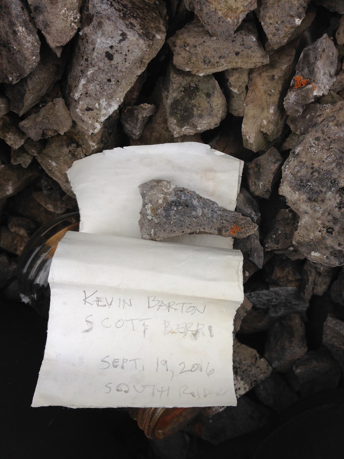
August 5 had an absolutely great day on the obscure, but grand, Mount Jerram. Mt. Jerram is located in the Opal Range, between Elpoca Mountain and Mount Burney.  This summit is the ninth highest in the Opal Range and one of the more significant mountains in this part of Kananaskis.  There were only two recorded ascents prior to our successful summit on August 5, 2016.  First ascent by Don Morrison and Jim Tarrant via West Ridge, then West Face to summit ridge and top in June of 1957.  Second ascent by Rick Collier and Jim Holmes on July 19, 1998, with a variation on the upper face to gain the summit ridge more to the north.  Andrew Nugara and I followed the Collier/Holmes variation to reach the summit.  Both previous parties did bivy in upper King Creek, but Andrew and I day tripped the climb with a long day, about 16 hours car to car.

Parked at Opal Creek turnoff, approach road to Valleyview Trail, along Highway 40, about 5 km south of the Peter Lougheed Provincial Park turnoff/King Creek parking lot.  A really great trail winds up northern edge of Opal Creek and leads one to the scree slope north of Opal Falls (White Man Falls). The trail starts just slightly upstream of the recently upgraded bridge (2016?) that crosses Opal Creek on the left side (north side) of creek. The lower section heads north, away from the creek on the top of the short bank, definitely worthwhile locating this trail.  After a short distance in the forest, the trail returns to the sharp northern edge of the creek valley and traverses to the open scree slopes, head north to a steep scree slope that heads east, uphill.  Ascending this steep scree slope is essential to accessing upper Opal Creek since the gap between Mt. Wintour and “Opoca Peak” (GR368155) is narrow and cliffy with Opal Falls creating a dangerous barrier.

Once above this steep scree, a huge trail leads one into the upper Opal Creek valley, where the trail disappears quickly, but mostly light bushwhacking allows easy access anywhere in this beautiful subalpine valley.  Hike to the obvious West Ridge of Mt. Jerram, basically above the Mt. Wintour/Mt. Jerram col, the Opal Creek/King Creek divide. The bottom of the West Ridge is vertical, so we accessed the middle section of the ridge via scree slopes from the basin between the West Ridge and the South-West Ridge. Moderate scrambling up the West Ridge ends a short flat section where ridge ends on the steep West Face. This is the first pitch of fifth class climbing, a nice 30 metre pitch of 5.4 on mostly solid rock, but little protection.


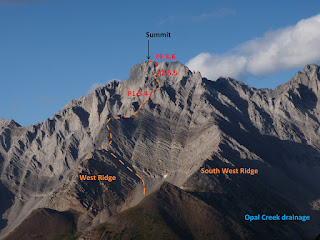
View to West Face of Mt. Jerram. Scramble in orange line, pitches of 5 class in red. Pitches labeled P.  
(Photo taken last fall, 2015)

Nearing start of scramble on middle section of West Ridge.

Typical terrain on mid section of West Ridge.

A few steeper sections on West Ridge.

Andrew having too much fun!

View to Mt. Burney from West Ridge; been there done that, also with Andrew.

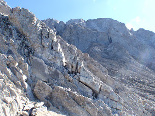
Once above this section, a scree slope heads up, then angles left, staying on scree, head up to a faint ridge line above, then from this ridge line, still 
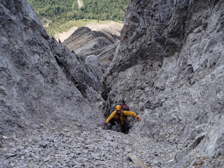
on scree, head up to the base of a dark gully. Two gullies start near the same spot, take the right hand gully (southern) which is taller and wider at the base.  The back of the gully was wet on our ascent.

View to 5.4 pitch.

Above 5.4 pitch, follow scree up, then left on scree.

OSWB leading 5.5 gully pitch.

Although technically easier, 5.5 versus 5.6, I would say this gully pitch is the crux, the moves are only 5.5, but you must stem crazy wide and totally commit to some very awkward moves to surmount the first overhang, not too technical, but demanding climbing; at least for me. Thankfully there is great protection from cam or wires along the lower section, right hand side, in the great hand crack, then less protection above the overhang, but the climbing is easier, 5.3 to 5.4 ish.

View to Andrew on second, finishing gully pitch.

OSWB above halfway up to the ridge on super loose 5.6; no pro.

About 30 metres in the gully leads to a scree gully that leads the top of a notch in the summit ridge. Belayed off a solid rock horn, brought up Andrew and set up for my last rock lead.  Rick Collier’s trip report indicated they went up to the notch, then took the ridge line (tower) out of the narrow notch to the summit. There was a small low angled slab face, then a steep face that lead directly to the ridge, I took this line instead of heading up scree to the notch; seemed more direct.  Definitely 5.6 climbing and extremely loose rock, but the worst rock quality section was where I gained the ridge, very exposed and the rock just peeled off the mountain. Once on the ridge the climbing became a loose moderate scramble to the summit cairn, about 30 metres from gaining the ridge.

Summit smiles.

On descent, OSWB taking a few last summit photos.

Summit view to Andrew at our first rappel station.

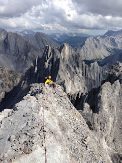
About 8 hours after leaving the car Andrew and I reached the seldomly 
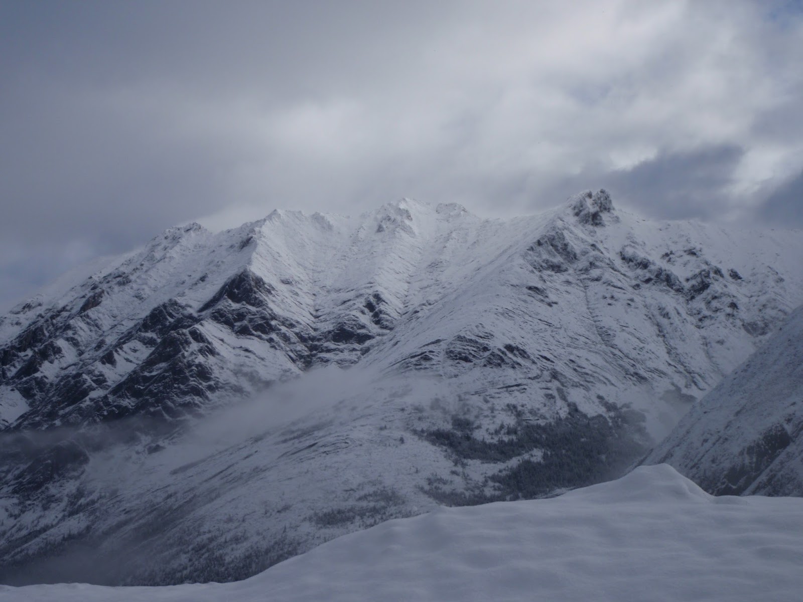
visited summit of Mount Jerram. The sky was a bit threatening with some dark cloud bottoms, but the advantage point and view from the summit was so spectacular we had to linger and take a lot of photos.  Filled out the register and slowly began our descent.  We used a piton placed by Rick Collier in 1998 as part of our first rappel station (backed up by a sling on a large boulder). Rapped to the top of the 5.5 gully pitch, rapped off the rock belay horn to the base on the gully; two rappels to the scree, good rappel anchors (cord with locking biner) left in place.  Rick and Jim were descending with a thunderstorm pending and to save time they avoided rappelling the lowest 5.4 pitch section by descending ribs and scree gullies along the big broad lower west face. We thought this could save time and tried this descent.  Not recommended.  I would recommend rapping the 5.4 section and descending the west ridge. The descent down the big face was painful with us getting cliffed out on top of many big drops that then required climbing up to attempt the next scree gully.  Big waste of time, but we eventually got down.


OSWB frigging around with the rope on the traverse rappel from the first rap station.


Andrew finishing rap of gully pitch.

View back up to gully pitch.

Upward view to left trending scree ramp that leads to 5.5 gully pitch, on descent.


Most of the way down the lower west face.

Back on scree fields, finally. 


Once back at the lowest scree field, just a simple plod back to the car. Nearing the cliffs near Opal Falls, we had a very tough time staying on the thin game trail by headlamp and wasted at least one hour traversing up and down trying to find the safe exit to the lower valley scree slopes; exhausting time.  Once back in the lower valley we were quite happy to plod to the car, about 16 hours car to car.  Great day out with a good friend and I will enjoy these memories for years!