Saturday, December 31, 2011

Ghost - Valley of the Birds (WI3-4)


Finally got out again this month;  I had about 3 or 4 trips cancelled last minute to due partner’s injuries, illness or lack of motivation.  Nice to be climbing again.  Jason, Janice and Pierre and I head to the Ghost for some ice climbing.  With a larger group we decided for a casual day with lots of options for ice climbs and headed to the Valley of the Birds.  Janice and I climbed Albatros (100m WI3) while J and Pierre headed to check out The Eagle.  


Well the Eagle hadn’t landed (bottom not formed, or had melted out) and the boys head to climb the Seagull.  I lead two easy  WI3 pitches on Albatros, very thin and poor quality ice on the first pitch, then hero easy ice on second pitch.  Good fun.


Janice and I rapped off, then all four of us head to Yellow Bird (60m WI4).  Easy first pitch lead to solid WI4 second pitch. J and Pierre lead the second pitch and I was happy to top rope the pumpy pillar, Janice also TR’d this great pitch.  Lots of sun and warm temperatures then cold beer at the truck, great holiday fun!


Saturday, December 10, 2011

Ex Slackcountry – Healy Pass


Great first day of the season on skis.  Headed to the extended slackcountry of Sunshine ;-), the Healy Pass area with Martin.


Warm temps and bluebird skies made for a nice causal tour into the Healy Pass area.  We followed the well set uptrack to a high point about 1.5 km north of the pass.  Low angled terrain with sparse tress, but fast snow made for a fun couple of laps.


Great day out. 

Wednesday, November 30, 2011

Planter's Valley - The Peanut Gallery WI4+

November 27 Jason and I headed to the Ghost for my first ice climb of the season.  We hiked into Planter's Valley, a spot where neither of us had been before.


There was a Chinook rolling in, typical situation with high winds in town and in the foothills, and dumping snow in the Main Range.  We lucked out and seemed to be on the edge of the two, no wind, and no snow; until we got a lot of mid afternoon snow.  The hike in felt like spring!  Very warm (+5 ish, 8 am) and no snow on the ground, with a light rain shower.  The first two climbs in the valley were not formed, so we head to the end of the valley, The Peanut Gallery.


The first pitch was about 60 metres of WI 3, my lead.  Generally good ice and my lead felt pretty good and generally pretty easy.
The upper bowl contains many ice and mixed lines, with the primary part of the drainage providing the largest sections of ice.  Further up the valley, the third and fourth pitches had larger and vertical pillars forming, but they had fallen off.


Jason and I spent a few hours on pitch two of Peanut Gallery, with JW leading the vertical, WI4+, pillars.  We climbed two lines, one very wet, one nice and dry.  Did a few top rope laps on the dry pillar.  Great day out with the young gun.

Friday, November 25, 2011

'Mount Schlee' - GR 385168

This summit in the Opal Range had the unofficial name of Mt. Schlee applied by Glen Boles after his team’s first ascent of the peak in 1976 (F.A. D. Forest, G. Scruggs, G. Boles and M. Simpson via South Ridge). 

This beautiful mountain reaches a height of 2850 metres (9,350 ft.) and is the second high point north of Elpoca Mountain, along the main ridgeline of the Opal Range. Gerrit Schlee was a friend of Boles and lost his life trying to save someone drowning in the Bow River in 1975. 


On Friday November 11, Andrew Nugara and I enjoyed this pleasant scramble with some snow and ice thrown in to make this simple ascent a bit more interesting. This peak likely provides great views of the Kananaskis Lakes region and the surrounding Opal’s, but we lost our views at treeline. The start of our day was warmer and calmer than we thought it would be as we left the Elbow Lake parking lot right at 8am.

Quick plod to Elbow Lake and along the main trail heading north beside the Elbow River. We cut over to the “Piper Creek” valley sooner then previous trips and make good time. We pushed onto treeline below our route and had a nice long lunch break. At 10:45 the weather and wind were still good, but increasingly thick and dark clouds would intermittently cover the summits of Elpoca and Rae.


We started our charge up the South East slopes and soon the weather changed for the worst. We lost our view and travelled in near white out conditions, snow began to dump and there was a howling gale. Nearing the summit there a bit of silly talk (Andrew ;-) about turning around, but we pushed on.


In summer conditions, this route would be a moderate scramble; but the rock hard snow and patches of water ice made the route much more difficult. We finally gave in put on crampons about 200 metres below the summit. The snow pack was only about 6 to 8 cm’s thick, but rock hard with the angle varying from 25 to 35 degrees, with sections of pretty good exposure. This icy surface layer would make any new snow quite dangerous if there was a significant amount. The upper SE face was mostly steep slab with thin scree cover, but usually enough for solid footing.


The final summit South Ridge had the odd steep and awkward step, but not too tough. Almost exactly 6 hours from the car, we stood on the very white summit of GR385168 ('Mt. Schlee'). Our stay was short, we quickly searched the cairn for a register, but there was none.


For our descent we wore crampons back to treeline, and this made the descent much safer and quicker. Quick break at our lunch spot and blasted back to the main Elbow trail and out to the car without headlamps. A nice 9.5 hours of very late fall fun.

Monday, October 10, 2011

Mount Victoria – North Summit, North East Ridge

On Saturday, October 8, Ian Hunt and I summited the North Summit of Mt. Victoria via the North Victoria/Collier Peak Col and North East Ridge.  Fantastic day!  I was getting very worried I would not get an 11,000’er in 2011, so this late season summit was a great gift.  Of the 25 11,000 foot summits I have reached, only North Victoria and Mt. Assiniboine were not completed on my first attempt. 


North Vic took me three attempts, third time the charm I guess (hopefully Assiniboine will only be 2 attempts ;-).  I was very happy to reach this cool summit with my old time climber partner Ian.  Although we haven’t done much the last few years, Ian was one of my mentors in my early years of alpine and water fall ice climbing; great to be out with the old guy again.


We left the Lake Louise parking lot at 6:30am, we were roped up and gaining the lower glacier at 9:30am and taking a rest at the schrund at 11:30am.   The upper glacier, most of the slopes below the col, and much of the North East Ridge had knee deep powder, so trail breaking was very tough.  There were isolated pockets of thin top layer wind slab, but the majority of the recent snow was very well bonded to the lower September and summer snow pack.

We gained the Collier/North Vic col by 1:30pm.  Much later than we hoped, but we had a long break, discussed conditions and energy levels and then decided to give’er. We topped out on North Vic about 3:15pm.  Occasional wind gusts pelted us with biting spindrift, but mostly conditions were quite nice.  Short stay, and then we heading down.  Nice to have buckets for the way down.  We were off the glacier at 6pm.


Quick romp back to the parking lot; about 13.5 hours car to car.  I think very good time concerning the huge amount of trail breaking. 

Lovely, lovely day.

Mt. Wintour - South Ridge, Alpine I, 5.4

On Saturday, September 10, the resolute Martin Siddles and I had a fantastic late summer day on little Mt. Wintour (2700m).  We ascended the faint East Ridge to the South Ridge then onto the summit; mostly moderate scrambling with one 30 metre pitch of 5.4 slab just below the summit. 

The Valleyview Road this road is now permanently closed, so we had to park just off the highway and hike up Opal Creek. Good trails on both sides of the creek, but best choice (we discovered on the way out) is to take the left (north side) trail, just where the creek meets the gravel road, up the bank, then up sharp ridge just above the north creek bank.

This trail leads to the gully north (left) of Opal Falls. This gully is loose and steep, but becomes wider and more stable near top. Once above Opal Falls, we found excellent game trails leading into Opal Creek, about 100 metres above creek once on the south slopes of Mt. Wintour.

Continue on good trails to round obvious steep rock buttress on south end of Wintour. Continue rounding north to intersect drainage from East Ridge of Mt. Wintour (about GR 365170) then up steep scree/dirt combo to East Ridge.


Where grass slopes end, head up East Ridge, slightly to right, up easy gully (looks steeper than it really is) and continue up gully to South Ridge. Once on the long summit ridge head north towards obvious summit.


Mostly moderate scrambling, but very, very loose and sections of high exposure. Route finding is easy, just stay on ridge top. From the gully access northward, before the halfway point to the summit, a few sections below the ridge, on the east side, would provide a respite from the high exposure, but we didn’t bother and just travelled on the sharp ridgeline. 
Moderate scrambling, with the odd short section of difficult steps, leads to the crux, about 120 horizontal metres from the summit. A steep rise in the ridge blocks easy travel. Here we stashed the poles and roped up.


We chose a line, left of the centre of the ridge, where a slab meets a steep wall, a good crack provided a belay station with two bomber nuts. Easy slab climbing (5.4) with good protection, with nuts, for 10 metres, then the line tended right onto easy ground (5.2), but no protection until a short corner. Climb short corner (5.4), with sketchy pro to easy ground above (30 metres from belay). Belay off rock piles, some more solid than others.


Easy scrambling to summit. Martin and I were about 4.5 hours to the top. We lounged and enjoyed the windless summit, hot sun and the mega blue bird sky. Back to the car in less than 3 hours from summit, all in, about 8 hours car to car. Great weather, great fun, recommended for a fun and short day of scree and exposure.

Thursday, October 6, 2011

Direttissima 325m, 5.8+ (9 pitches)

August 29 climbed Direttissima with Jason Wilcox.  The climb has some new bolted anchors which will increase safety since some of the old piton stations are a bit suspect.  Rest of the route is in "old school" fashion. We only found one other bolt on route that was not an anchor, and it was beside a manky corner that had lots of loose rock.  Lots of old rusty pitons on route as well, most of which we clipped and they seemed solid.


The climbing was full value and then some for 5.8.  The grade of 5.8 should be taken in light of the date of first ascent (1957).  Bow Valley Rock said that "by Yam standards it is easy for its grade" I would disagree, but I haven’t climbed much on Yam. 


Jason and I were both slow and worked hard on our leads; goes without saying Jason lead most of the pitches and all the tough ones, 5.7 or higher.


Looking down the first pitch (5.8+, 50m), upper corner very sustained (old school 5.8) and has polished sections.  


Jason fought a lot of rope drag on pitch 5, much easier on top rope and the slick feet were less of an issue for me to stem up the awkward corner.  

Looking down top of pitch 5 from station.

Looking back at Jason at station 6 when I am leading pitch 7, packed away camera after this shot since the climbing got tougher.

Why doesn't JW have his hands on the rope?

JW grunted his way around the big chockstone, just off the belay staiton, for the start of pitch 9. Stemming was the best option, but the left wall is very slick, again easier for me on TR.  You have to take off your pack for the squeeze through behind the next chockstone, and don't forget to belay the second with a bit of slack in this section, as they will need to reach back down to get their pack.


For gear, we took 12 draws/runners, which I think we used all of them on a few pitches, and we used 0.5-3 cams and med to large nuts.  Any nuts BD size 6 and under we found no use for. You could double up on 0.5, 0.75 and #2 cams, as they seemed to get used a lot.

We had a super hot day to start so the bits of shade were awesome.  Great to follow the tough pitches and top out on the summit.  


Wednesday, October 5, 2011

‘Mount Denny’ (GR 338277)

Saturday August 27, I had an enjoyable solo day in the Opal Range. ‘Mount Denny’ (GR 338277) is a fun moderate scramble two summits north of Mt. Evan-Thomas in the Opal Range. The prolific Glen Boles applied the unofficial name of ‘Mount Denny’ to this peak after his team’s (G. Boles, D. Forest and M. Simpson) first ascent of the more northern summit in July of 1973 (first ascent of southern summit by John Martin in March 1973 (solo)).  Cecil Denny and Jerry Potts were key in the established of the RCMP (then the NWMP) in Alberta. 1973 was the 100 th anniversary of the RCMP, thence Boles’ suggestion.
The toughest part of this scramble is the hike up Grizzly Creek. I recommend that when up the creek about 1 km from highway, take the game trails on the north side of the creek. Just as the creek narrows into a tight canyon with a waterfall, an excellent trail presents itself on the left (north) side, take this trail into the upper reach of Grizzly Creek. 
Hike southward, past ‘Mt. Potts’ (GR 340267) to the south-west slopes of Mt. Denny. About 3 hours takes you to the base of scramble; aim for the obvious short cliff band, above a scree cone, likely to have a snow patch (there was a snow patch on Aug. 27), a small waterfall, or ice, depending on the time of year.


An easy gully to climber’s right bypasses this overhanging rock band. Once above the band, you have a choice of loose scree, or fun hands on moderate to difficult scrambling, based on line of ascent. 


I mostly stayed left (north) of the primary gully system and enjoy lots and lots of steep slab with moderate/difficult scrambling most of the way to the southern summit (GPS reading 3003m); about 5.5 hours from the car. Easy scree and slab northward reaches the northern summit in about 10 – 15 minutes (GPS reading 3000m). Only a register on the southern summit.


On the descent I managed to stay on scree for about 95% of the elevation loss to the rock band. Just above the overhanging band I went to skier’s right hoping to stay on scree. Bad call, short, but difficult downclimbing got me back on scree north of the scree cone. Quick plod down Grizzly Creek, lots of sheep and goats, and back to the car in less than 4 hours from northern summit. Total 10 hours car to car.


Tombstone Mountain - North Ridge, North Tower of Tombstone Mountain, Alpine II, 5.5

On Sunday August 7, 2011 Andrew Nugara, Rafal Kazmierczak and I climbed Tombstone Mountain (North) via the North Ridge. The majority of the route we took is a walk up, with the final summit ridge providing difficult and exposed scrambling and two short pitches of rock climbing ranging from about 5.2 to 5.5.
This summit is not labelled on the NTS map, Kananaskis Lakes 82 J/11, but a few sources, including Alan Kane, indicate the label of “Tombstone Mountain” is incorrectly applied on 82 J/11. The northern summit at GR401182 is higher than the more southerly peak, the mountain labelled as “Tombstone Mountain” on 82 J/11, and often called Tombstone South. 82 J/11 shows the highest contour on GR401182 as 3000m and on Tombstone South (GR 408167) as 2920m.
Andrew had some old trip reports, we had all read the “Green Book” (Rocky Mountains of Canada: South, Boles, Kruszyan & Putman, 1979) route descriptions, and I had climbed a new rock route on a west rib of Mt. Tombstone back in 2003 (failed to reach the summit because of a raging thunderstorm); so we felt confident about reaching the summit of this obscure peak.
With a causal pace, and success at finding the “Piper Creek” trail, we made reasonable time to the Jerram/Tombstone col (GR 392178) just under 4 hours. The display of wild flowers was exquisite in the upper alpine meadows. I had hoped to ascend the West Ridge route, then continue on to bag all 3 summit pinnacles, and then descend the same gully system I had used in 2003. After our chat at the col, we decided the lower gendarmes of the West Ridge looked time consuming, so we decided to descend to the north, to a nice tarn (GR 391182), have lunch, then bypass the gendarmes by slogging the north-west scree slopes to the West Ridge above these features.

After an enjoyable lunch and scree slog, we reached the mid section of the West Ridge, where moderate scrambling, then difficult scrambling, on poor rock, brought us to the summit ridge. 
The access to gain the NW/SE oriented summit ridge was difficult and very exposed, with poor rock quality and plenty of slab covered with pebbles, good times! Rafal’s excellent route finding skills got us through the exposed slabs to the summit ridge without the need of a rope (good luck finding a solid anchor ;-).

The first section of the summit ridge was more of the same (difficult and very exposed scrambling, with poor rock quality) for about 150 metres of horizontal travel towards the northern most summit pinnacle. Just before the summit, a notch in ridge presented the crux of the route. After attempting a very loose and very scary downclimb, I retreated back to the ridge and set up a rappel anchor. 

We rappelled into the notch. The climb to the summit pinnacle was about 45 metres of slab, then steep ridge, maybe 5.2 to 5.3, with very little opportunity for protection. Once near the summit, I belayed Rafal and Andrew to my lovely exposed anchor just below the summit.

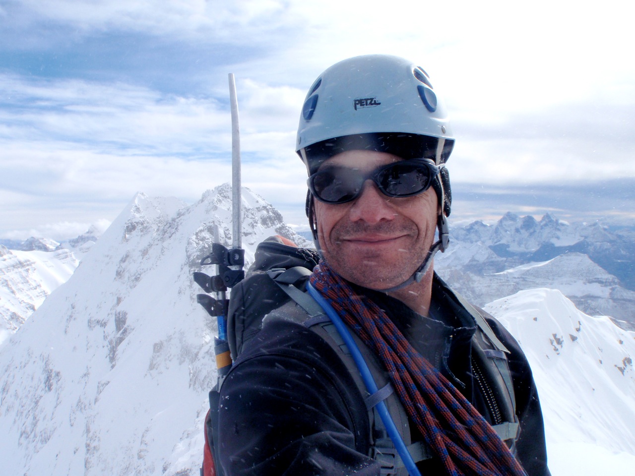
The final summit was a narrow, very exposed ridge, with a few rocks making up the summit cairn; no register or any other summit markers. Since we had taken 10 hours to reach this exposed summit, my original plan to traverse to other two lower summit pinnacles, was obviously not going to happen. Also the travel south towards the other pinnacles was extreme. We did relax a bit and enjoy the unique perspective from this obscure summit before heading down. Considering how long it took to reach the summit, it only took us 5 hours from the summit to the car.

Quick downclimb about halfway into the notch where we set up a rappel anchor, and rappelled back to the bottom of the notch. The up climb back north out of the notch was the climbing crux, maybe 5.4 or 5.5 on thin slab, then dusty choss back to the first anchor. 
We made quick travel on the summit ridge back to the West Ridge intersection, then decided to descend West Ridge to the lower gendarmes. At the lower gendarmes the Mountain Gods smiled upon us; steep scree gullies lead south back to “Piper Creek”.


Hoping to maximize daylight, we sent a quick pace downhill back towards the Elbow River, crossed the river and made the main Elbow Trail at full darkness. Plod by headlamp and back to the parking lot. All in, a solid 15 hours car to car. A great summer day in the hills.